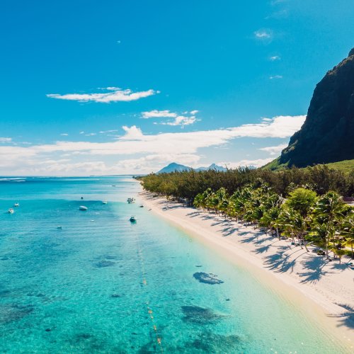
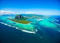
The sheer cliff of the square-shaped Morne Brabant (556m) rises dramatically out of the southern peninsula, dominating the west coast of the island with its looming presence. Runaway slaves fled to Le Morne during the 18th and early 19th centuries, taking refuge in its caves. On 1 February 1835, fearing that the police party sent to tell them slavery was abolished had come to capture them, the slaves threw themselves off the summit to their deaths. A sadness haunts the mountain still. A community for freed slaves was set up at the southern foot of Le Morne but was later moved to the present location of Le Morne village. Their descendants still live there today and regard Le Morne, which came to symbolise the suffering of the island’s slaves, as sacred. In 2008 Le Morne was declared a UNESCO World Heritage Site and the following year UNESCO unveiled a memorial at the foot of Le Morne, as part of its Slave Route Project. The International Slave Route Monument (( 09.30–16.00 Tue–Sat, 09.30–12.30 Sun) lies just beyond the Dinarobin Hotel, across the road from the public beach. At its centre is a black granite block engraved with the image of a slave, around which are a series of stones and sculptures symbolising the countries from which the slaves came. In front of the memorial is inscribed in Creole, French and English, a verse of the poem ‘Le Morne. Territoire Marron!’ by Sedley Assone:
There were hundreds of them, but my people the maroons chose the kiss of death over the chains of slavery.Never must we forget their noble deed, written in the pages of history for the sake of humanity.
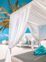
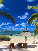
Large hotels and some upmarket homes now lie at the foot of Le Morne; it is a breathtaking setting between the austere cliff and the gentle beaches. Between the hotels, there is access to the pleasant public beach and a large, shallow lagoon. On weekends families of Mauritians come here to picnic and it is popular with kitesurfers.
The foothills of the island’s highest mountain, Piton de la Petite Rivière Noire (Little Black River Mountain – 828m), reach down to the road near La Gaulette. A French soldier called Noyale retired to the area on the coast now known as Case Noyale. He was renowned for his hospitality and built a resthouse at Petite Case Noyale, but was murdered by runaway slaves.
There is a turning next to the church at Grande Case Noyale that leads to Chamarel and into the Black River Gorges National Park. It is a steep, winding road with spectacular views of the coast, Le Morne Brabant, Ile aux Bénitiers and the countless colours of the lagoon. About 6km from the coast is the village of Chamarel, which lies amidst fields of pineapples and sugarcane. There are two popular restaurants in the vicinity: Le Chamarel, just before the village, and the Varangue Sur Morne, a further 4km towards the national park. Both have splendid views.
Taxi drivers repeat the words ‘seven coloured earths of Chamarel’ as a litany that will bring them business. There is, indeed, an exposed heap of colourful clinker on a private estate just south of Chamarel village. The piles are remarkable for being an exposed part of the stratum under the earth’s crust. The ‘seven colours’ are best seen with the sun on them. Some people marvel at them whilst others are disappointed having heard so much hype. Also on the estate is a waterfall, which plunges 100m down a sheer cliff face. Chamarel is known for its coffee, although buying a sample is not as easy as you may think as most is sold to hotels or Curepipe supermarkets. There is a shop at Le Chamarel restaurant which sells it, as does the souvenir shop at the ‘seven coloured earths’.
On the main road through Chamarel, 3km from the village in the direction of Grand Bassin, is La Rhumerie de Chamarel, which explains the process of producing rum from sugarcane.
The Chamarel road continues up to the forest plateau of Plaine Champagne, at 737m above sea level. Off this road is a viewpoint overlooking the Black River Gorges National Park and a second viewpoint with views of Alexandra Falls and the coast. The area is part of the nature reserve and glimpses of deer, monkeys and mongoose are likely.
Returning to the coast road, mountains are the main feature of the landscape on the drive towards Port Louis. Beyond the Black River mountain range is Simonet (632m), in the Vacoas mountain range, overlooking the plain between Montagne du Rempart and Yemen to the sea at Tamarin. By the coast is Tourelle du Tamarin (548m), but it is the profiles of the upturned, udder-like Trois Mamelles (629m) and the mini Matterhorn, Montagne du Rempart (777m), which are so impressive.
In the village of Grande Rivière Noire, the Black River Aviary is hidden away near the wooden Creole building which houses the police station. Visitors are not allowed, except by arrangement, as this is a sponsored scientific project run by the Mauritian Wildlife Foundation to encourage the breeding of rare species of birds which might otherwise become extinct. However, Mauritius kestrels can sometimes be seen flying around the area having ventured from their nesting boxes. There is a visitor’s centre for the Black River Gorges National Park just inland from Grande Rivière Noire on Les Gorges Road.
Between Grand Rivière Noire and Tamarin is the popular Ruisseau Creole shopping centre, with over 50 shops and numerous restaurants . The modern shopping centres and housing developments in the area are indicative of the recent influx of foreigners to the area, particularly South Africans.
The road to Tamarin runs beside salt pans, where seawater flows through a series of pools and via evaporation produces salt. Salt pans were introduced to Mauritius during French rule (1715–1810) and the ones you see here have been producing salt for over 175 years. In the early morning, ladies can be seen shovelling the salt and carrying it on their heads to the salt stores. If you think they look too heavily dressed for the weather, in their wellington boots and long skirts, the clothing is necessary to protect their skin from the salt. Guided tours explaining salt production are available
The beach at Tamarin has waves, unlike many of the northern and eastern beaches, and so is popular with surfers.


 100% Privacy Guaranteed